
Tateyama Kurobe Alpine Route
The Japanese Alps for Everyone
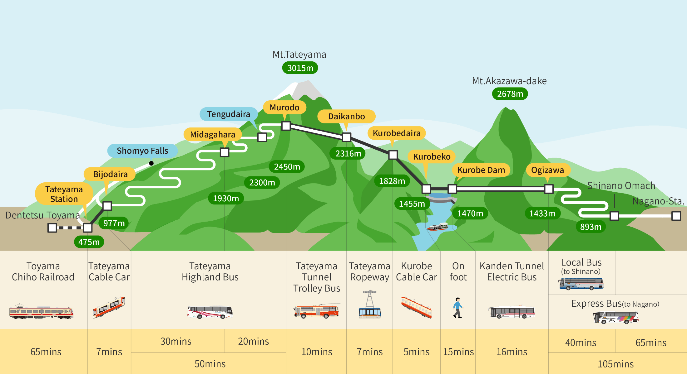
Tateyama Kurobe Alpine Route is a touristic attraction located in the north of the Japanese Alps. It connects Toyama and Nagano prefectures thanks to a dedicated course on Tateyama sacred mountain and climbs up to 2,450 meters above sea level. Wonderful natural landscapes unfold and are traversed using several types of public transports.
Mount Tate is one of the three sacred mountains of Japan (三霊山 Sanreizan) along with Mount Fuji 🗻 and Mount Haku, and one of the favorites of Japanese people. To be more precise, Tateyama is a mountain range including three summits:
- Mount Oyama (3,003 meters above sea level),
- Mount Oonanjiyama (3,015m); and,
- Mount Fuji-no-oritate (2,999m).
The site is also part of the Chubu Sangaku National Park.
In the early 1970’s, the road was created in the mountain, that is traversed by two several kilometers-long tunnels drilled under the massif. The technical and human challenge gave birth to one of the most famous destinations in the Japanese Alps: Tateyama Kurobe Alpine Route. The route itself constitutes an impressive landscape, going above the clouds and letting visitors think they travel on the top of Japan.

Five travel modes to traverse the mountain
The Alpine Route is about 37 kilometers (about 23 miles) long and goes up to 2,450 meters above sea level. This route is only accessible by public transport to preserve the surrounding nature and keep tourism attendance under control. Therefore, traffic of private vehicles is prohibited. Consequently, five different modes are available to travel Tateyama Kurobe Alpine Route:
- Two cable-cars (tramways), one outdoor and one in a tunnel dug into the rocks,
- A ropeway above the valley,
- Two bus lines, on the winding road,
- One electric bus + a trolleybus, in the underground tunnels; and,
- Walk, to admire the scenery.
What are the natural sites on the Alpine Route?
Depending on the side considered from Tateyama mountain range, the route can be divided into two geographical areas:
- The western side, near Tateyama station, where most of the natural sites are located (probably the most interesting part of the route for hiking);
- And the eastern side, near Ogizawa station (for the bus) and Shinano-Omachi station (for the train) granting access to Kurobe area.
We selected the most beautiful stopovers on the Alpine Route, starting from Tateyama.
Shomyo Falls
It is one of the tallest waterfalls in Japan. Depending on the season, one to three waterfalls can be seen, that fall from more than 350 meters high. The bridge above the river is the perfect observation point.
Shomyo Falls are served by a dedicated bus line from Tateyama station (not included in the Alpine Route itinerary). Then a half an hour walk is necessary to reach the viewing site.
Bijodaira Primeval Forest
This forest on the mountain side is characterized by a lush nature reminding of tropical jungle. Several hiking trails wind between millennium-old cedar trees and beeches. Some of their trunks are so huge that it is possible to enter inside. About sixty bird species live in this natural environment.
The hike can start from Bijodaira station, on the top of Tateyama cable car 🚙. Hikes can last about one to two and a half hours.
Midagahara Wetlands
This tableland spreading between 1,600 and 2,100 meters above sea level was formed by Tateyama volcano 🌋’s lava. Nowadays, the marshland is dotted with countless small ponds and many species of Alpine flowers and plants to discover during beautiful days.
The hiking trails tend to be levelled and the signage is good, with parts of the walking path built on walk boards to protect the local flora. Depending on the weather conditions, the mist covers the moor and bestows an even more isolated and eerie atmosphere to the landscape.
Yuki-no-Ootani Snow Corridor
Yuki-no-Ootani’s snow walls are the iconic landmark of the Alpine Route, but they are only visible for a short period: between mid-April to mid-June, in the early days of the reopening of the site at the beginning of spring 🌸. Two bulldozers dig the snow during seven to ten days to clear the road and open it to traffic again. The huge mass of snow that fell during winter is visible along the road and forms tall white cliffs that can be twenty meters high on the best years.
Part of the bus road is open to pedestrians for the occasion. The snow corridor is one of the tourists’ favorites, so it is best to arrive as early as possible in the morning to enjoy the quietness of the place, all the more as it closes in the middle of the afternoon.
Nearby, a panoramic view allows to have a glimpse on the road on its whole. A shelter entirely dug in the snow, and a labyrinth are arranged to entertain visitors of all ages.
Murodo Station
It is the highest place of the Alpine Route, as it culminates at 2,450 meters above sea level. Both a bus station and a mountain resort, it offers a wide range of hikes and many conveniences thanks to its hotels 🏨 and restaurants.
The hikes available cover the plateau’s marked-off areas with easy and pleasant walks enlightened by many vistas on the mountain range. It is also possible to start from Murodo to climb mountains such as Mount Oyama.

Daikanbo Station
On the eastern side of Tateyama mountain range, with the mountain on the back, Daikanbo Station’s observatory offers a wonderful view on the steep area. The only way to reach the ropeway, this platform hanged at 2,316 meters high is worth the trip with its bird’s eyes view on the valley and the lake formed by Kurobe Dam beneath.
Two observation decks are available for visitors, and we recommend the highest one, fitted with large tables for outdoor picnic and where the beautiful colors of autumn 🍁 are especially enjoyable.
Kurobe Dam
Kurobe Dam is the highest in Japan, and the only part of the Alpine Route that one must walk to reach Mount Akazawa-dake located in front of Tateyama.
While walking on the dam, several observation platforms offer vistas on the two sides of the gigantic architecture (that discharges ten tons of water per second).
A unique and picturesque trip at each season
Tateyama Kurobe Alpine Route combines several altitude records and is among the most picturesque roads of Japan, in the heights of the Japanese Alps. To better enjoy the variety of natural sites and the quietness of the mountain, we recommend travelling this route at least over two days, and to stay, for example, one night in Murodo.
Autumn, between mid-September and early October is one of the best times of the year to take this road with a minimal touristic attendance, vivid colors enlightening the landscape and the last beautiful sunny days before the advent of winter and snowfalls.